Jump to content

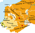
File:Burgundian northern France 1465–1477.png

Page contents not supported in other languages.
This is a file from the Wikimedia Commons
From Wikipedia, the free encyclopedia

Burgundian_northern_France_1465–1477.png (416 × 399 pixels, file size: 92 KB, MIME type: image/png)

Description
English: Territories of the House of Valois-Burgundy during the reign of Charles the Bold, 1465/67–1477
Date 2.5.2008
Source Own work
Author Marco Zanoli (sidonius 12:09, 2 May 2008 (UTC))
Permission
(Reusing this file)

You may use my work outside wikipedia for free as long as you name me as the author. If you would like to use my work in a print medium, please send me a specimen copy. Contact me if you have questions regarding the license or if you want individual changes to the map (marco.zanoli at hotmail.ch).

w:en:Creative Commons
attribution share alike
This file is licensed under the Creative Commons Attribution-Share Alike 4.0 International license.
Attribution: Marco Zanoli
You are free:
  • to share – to copy, distribute and transmit the work
  • to remix – to adapt the work
Under the following conditions:
  • attribution – You must give appropriate credit, provide a link to the license, and indicate if changes were made. You may do so in any reasonable manner, but not in any way that suggests the licensor endorses you or your use.
  • share alike – If you remix, transform, or build upon the material, you must distribute your contributions under the same or compatible license as the original.
Other versions
image extraction process
This file has been extracted from another file
: Karte Haus Burgund 4 EN.png
original file
Coat of arms from: ;
German version:
Version française :
中文版:

Captions

Add a one-line explanation of what this file represents

Items portrayed in this file

depicts

image/png

75b641555a5ee5729c21148910a85c1673a8317e

94,647 byte

399 pixel

416 pixel

File history

Click on a date/time to view the file as it appeared at that time.

Date/TimeThumbnailDimensionsUserComment
current01:58, 13 July 2020Thumbnail for version as of 01:58, 13 July 2020416 × 399 (92 KB)Nederlandse LeeuwFile:Karte Haus Burgund 4 EN.png cropped 65 % horizontally, 76 % vertically using CropTool with precise mode.

Global file usage

The following other wikis use this file:

Metadata