File:Sugbumap.png
Appearance

Size of this preview: 462 × 599 pixels. Other resolutions: 185 × 240 pixels | 370 × 480 pixels | 592 × 768 pixels | 790 × 1,024 pixels | 1,580 × 2,048 pixels | 2,604 × 3,376 pixels.
Original file (2,604 × 3,376 pixels, file size: 241 KB, MIME type: image/png)
File history
Click on a date/time to view the file as it appeared at that time.
| Date/Time | Thumbnail | Dimensions | User | Comment | |
|---|---|---|---|---|---|
| current | 03:20, 11 September 2023 |  | 2,604 × 3,376 (241 KB) | Delirium333 | improved topography resolution |
| 13:17, 10 September 2023 |  | 2,604 × 3,376 (269 KB) | Delirium333 | improved accuracy, less reliance on aginid which is most likely fiction | |
| 04:07, 6 September 2022 |  | 1,800 × 1,693 (59 KB) | Delirium333 | I made changes because there was no actual proof of much habitation in Northern Cebu until the 1800s. It is a surprising discovery but pretty weird. So I had to change this map. | |
| 12:12, 27 June 2022 |  | 1,800 × 1,693 (59 KB) | Delirium333 | fixed accuracy because im dumb | |
| 05:17, 27 June 2022 |  | 1,800 × 1,693 (60 KB) | Delirium333 | added katugasan, a precolonial kedatuan in siquijor | |
| 04:59, 27 June 2022 |  | 1,800 × 1,693 (60 KB) | Delirium333 | improved accuracy and quality | |
| 02:02, 27 March 2021 |  | 2,727 × 3,750 (118 KB) | Delirium333 | Apparently the whole island was a subordinate to the Rajahnate so I had to change it. | |
| 13:15, 23 March 2021 |  | 2,727 × 3,750 (118 KB) | Delirium333 | Border changes. | |
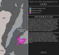
| 08:11, 23 March 2021 |  | 2,727 × 3,750 (118 KB) | Delirium333 | Map of the Rajahnate of Cebu/Sugbu during 1521. |
File usage
The following 3 pages use this file:
Global file usage
The following other wikis use this file:
- Usage on bn.wikipedia.org
- Usage on id.wikipedia.org
- Usage on ko.wikipedia.org
- Usage on tl.wikipedia.org
