Armathwaite
| Armathwaite | |
|---|---|
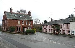
 The Duke's Head Inn in Armathwaite | |
| OS grid reference | NY505461 |
| Civil parish | |
| Unitary authority | |
| Ceremonial county | |
| Region | |
| Country | England |
| Sovereign state | United Kingdom |
| Post town | CARLISLE |
| Postcode district | CA4 |
| Dialling code | 016974 |
| Police | Cumbria |
| Fire | Cumbria |
| Ambulance | North West |
| UK Parliament | |
Armathwaite is a village in the English ceremonial county of Cumbria.
Historically within the county of Cumberland, Armathwaite lies on the River Eden, forms part of the Westmorland and Furness district and is served by Armathwaite railway station. The majority of the village is in Hesket civil parish but with some buildings in the parish of Ainstable and others on the outskirts of the village located in the parish of Wetheral, within the City of Carlisle district. The castle on the west bank of the river was originally a pele tower with a large but undistinguished Edwardian extension.
The parish church of Christ and St Mary[1] was formerly a chapel-of-ease in the parish of Hesket-in-the-Forest and is one of the smallest parish churches in England. By the 17th century the original chapel had become ruinous but it was rebuilt before 1688 by Richard Skelton of Armathwaite Castle. It consists of a chancel and nave with a wooden roof and a small western bell turret.[2]
The town of Armathwaite in Fentress County, Tennessee was named by Alwyn Maude, who was from the Armathwaite area (then in Cumberland) and who arrived in Tennessee about 1881 and settled in the Rugby Colony.[3] Richard Tomlinson (former spy) spent his childhood in Armathwaite.[4]
An application to erect a wind turbine on a ridge to the south east of the village was considered by Eden District Council in 2014 and turned down. The application attracted 3 letters of support and 895 letters of objection.[5][6] Another wind turbine application for nearby Aiketgate is being considered by the Harmony Energy Ltd. on land at Barrock End Farm.[7]
Armathwaite Golf Club (now defunct) was founded in 1907. The club disappeared following WW1.[8]
See also
[edit]- Armathwaite Castle
- Armathwaite Nunnery
- Listed buildings in Ainstable
- Listed buildings in Hesket, Cumbria
- Low House Estate
References
[edit]- ^ Armathwaite: The Church of Christ and St Mary on A Church Near You
- ^ Betjeman, J. (1968) Collins Pocket Guide to English Parish Churches: the North. London: Collins; p. 108
- ^ Wanda Sewell Hatfield, "Armathwaite, Mount Helen, Shirley, and Honey Creek Communities," History of Fentress County, Tennessee (Fentress County Historical Society, 1987), p. 19.
- ^ "Parents of jailed former MI6 man 'very disappointed'". Cumberland and Westmorland Herald. 20 December 1997. Retrieved 20 August 2020.[permanent dead link]
- ^ 'Wind turbine plans attract more than 1,000 objections' in The Cumberland and Westmoreland Herald 19.7.2014
- ^ 'We will continue our fight against turbines' in The Cumberland News 25 July 2014. Ainstable Turbine Action Campaign Group was set up to oppose the application.
- ^ 'Don't alter our skyline' 'residents to oppose plans for 77 metre high mast' The Cumberland News 25.7.2014 page 19.
- ^ “Armathwaite Golf Club”, “Golf's Missing Links”.
External links
[edit]- Cumbria County History Trust: Hesket in the Forest (nb: provisional research only – see Talk page)
- Illustrated guide
- Armathwaite community site
- Map sources for Armathwaite


