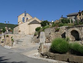
Dorres
Dorres | |
|---|---|
 The centre of the village in 2013 | |
| Coordinates: 42°29′08″N 1°56′23″E / 42.4856°N 1.9397°E | |
| Country | France |
| Region | Occitania |
| Department | Pyrénées-Orientales |
| Arrondissement | Prades |
| Canton | Les Pyrénées catalanes |
| Intercommunality | Pyrénées Cerdagne |
| Government | |
| • Mayor (2020–2026) | Alain Colomer[1] |
Area 1 | 24.77 km2 (9.56 sq mi) |
| Population (2021)[2] | 173 |
| • Density | 7.0/km2 (18/sq mi) |
| Time zone | UTC+01:00 (CET) |
| • Summer (DST) | UTC+02:00 (CEST) |
| INSEE/Postal code | 66062 /66760 |
| Elevation | 1,332–2,827 m (4,370–9,275 ft) (avg. 1,450 m or 4,760 ft) |
| 1 French Land Register data, which excludes lakes, ponds, glaciers > 1 km2 (0.386 sq mi or 247 acres) and river estuaries. | |
Dorres (French pronunciation: [dɔʁ] ; Catalan: Dorres) is a commune in the Pyrénées-Orientales department in southern France.
Geography
[edit]Localisation
[edit]Dorres is located in the canton of Les Pyrénées catalanes and in the arrondissement of Prades.

History
[edit]Various tools and evidence of occupation found in the surroundings prove that the territory of Dorres was already occupied in prehistoric times.[3]
At the end of the 9th century, Dorres was a property of Sunifred (who died ca. 890), a son of Sunifred, count of Cerdanya. Having become the abbot of the Abbey of Arles-sur-Tech, Sunifred then gave Dorres to his nephew and godson Radulf, himself the son of Wilfred the Hairy and future bishop of Urgell. Later, in the 12th century, is found the name of Guillem de Edorres, supposed to be the local lord. From the 14th century, Dorres becomes part of the crown estate.[3]
Being mainly mountain territory, Dorres was never much populated and reached its peak of population in 1851, with about 366 people, and it was yet until the end of the 19th century that locals were attacked by wolves.[4]
Population
[edit]Graphs are unavailable due to technical issues. Updates on reimplementing the Graph extension, which will be known as the Chart extension, can be found on Phabricator and on MediaWiki.org. |
| Year | Pop. | ±% p.a. |
|---|---|---|
| 1968 | 171 | — |
| 1975 | 154 | −1.48% |
| 1982 | 156 | +0.18% |
| 1990 | 192 | +2.63% |
| 1999 | 219 | +1.47% |
| 2007 | 179 | −2.49% |
| 2012 | 162 | −1.98% |
| 2017 | 169 | +0.85% |
| Source: INSEE[5] | ||
Sites of interest
[edit]- Notre-Dame-de-Belloc chapel.
- Saint John church.
- Magette chapel.
- Hot springs of sulfur water.
See also
[edit]References
[edit]- ^ "Répertoire national des élus: les maires". data.gouv.fr, Plateforme ouverte des données publiques françaises (in French). 2 December 2020.
- ^ "Populations légales 2021" (in French). The National Institute of Statistics and Economic Studies. 28 December 2023.
- ^ a b (in French) Jean Sagnes (dir.), Le pays catalan, t. 2, Pau, Société nouvelle d'éditions régionales, 1985
- ^ Cardenas, Fabricio (20 February 2015). "Attaques de loups en Cerdagne en 1864". Vieux papiers des Pyrénées-Orientales (in French). Retrieved 27 October 2016.
- ^ Population en historique depuis 1968, INSEE


