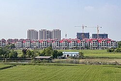
Fengtai County
Appearance
Fengtai
凤台县 | |
|---|---|
 Maoji, Fengtai County | |
 | |
| Country | China |
| Province | Anhui |
| Prefecture-level city | Huainan |
| County seat | Fenghuang |
| Area | |
• Total | 894 km2 (345 sq mi) |
| Population (2020) | |
• Total | 633,385 |
| • Density | 710/km2 (1,800/sq mi) |
| Time zone | UTC+8 (China Standard) |
| Postal code | 232100 |
Fengtai County (simplified Chinese: 凤台县; traditional Chinese: 鳳台縣; pinyin: Fèngtái Xiàn; lit. 'phoenix platform') is a county in the north of Anhui Province, China. It is under the administration of Huainan city. Author Li Hengrui (李恒瑞), whose work "Kite Capriccio" (風箏暢想曲) describes life as a child in the 1950s in Fengtai County is included in the Putonghua Proficiency Test.[1]
Administrative divisions
[edit]In the present, Fengtai County has 15 towns, 3 townships and 1 ethnic township.[2]
- 10 Towns
|
|
- 3 Townships
- 1 Ethnic township
- Lichong Hui Ethnic Township (李冲回族乡)
Climate
[edit]| Climate data for Fengtai (1991–2020 normals, extremes 1981–2010) | |||||||||||||
|---|---|---|---|---|---|---|---|---|---|---|---|---|---|
| Month | Jan | Feb | Mar | Apr | May | Jun | Jul | Aug | Sep | Oct | Nov | Dec | Year |
| Record high °C (°F) | 20.5 (68.9) |
27.3 (81.1) |
29.2 (84.6) |
34.1 (93.4) |
37.3 (99.1) |
39.1 (102.4) |
40.1 (104.2) |
37.7 (99.9) |
37.6 (99.7) |
33.3 (91.9) |
29.0 (84.2) |
22.4 (72.3) |
40.1 (104.2) |
| Mean daily maximum °C (°F) | 6.7 (44.1) |
9.8 (49.6) |
15.2 (59.4) |
21.7 (71.1) |
27.1 (80.8) |
30.4 (86.7) |
32.0 (89.6) |
31.1 (88.0) |
27.4 (81.3) |
22.5 (72.5) |
15.7 (60.3) |
9.0 (48.2) |
20.7 (69.3) |
| Daily mean °C (°F) | 2.3 (36.1) |
5.1 (41.2) |
10.1 (50.2) |
16.4 (61.5) |
21.9 (71.4) |
25.9 (78.6) |
28.2 (82.8) |
27.2 (81.0) |
22.8 (73.0) |
17.3 (63.1) |
10.7 (51.3) |
4.5 (40.1) |
16.0 (60.9) |
| Mean daily minimum °C (°F) | −1.1 (30.0) |
1.4 (34.5) |
5.9 (42.6) |
11.7 (53.1) |
17.2 (63.0) |
21.8 (71.2) |
25.0 (77.0) |
24.1 (75.4) |
19.3 (66.7) |
13.3 (55.9) |
6.8 (44.2) |
1.0 (33.8) |
12.2 (54.0) |
| Record low °C (°F) | −15.5 (4.1) |
−13.3 (8.1) |
−5.0 (23.0) |
0.1 (32.2) |
5.0 (41.0) |
12.2 (54.0) |
18.1 (64.6) |
14.9 (58.8) |
9.6 (49.3) |
1.0 (33.8) |
−8.1 (17.4) |
−16.8 (1.8) |
−16.8 (1.8) |
| Average precipitation mm (inches) | 33.5 (1.32) |
37.3 (1.47) |
58.1 (2.29) |
56.0 (2.20) |
79.3 (3.12) |
164.2 (6.46) |
209.4 (8.24) |
135.8 (5.35) |
77.9 (3.07) |
50.4 (1.98) |
41.7 (1.64) |
23.8 (0.94) |
967.4 (38.08) |
| Average precipitation days (≥ 0.1 mm) | 7.0 | 7.9 | 8.5 | 7.8 | 9.2 | 9.3 | 12.0 | 11.9 | 8.4 | 7.4 | 7.9 | 6.0 | 103.3 |
| Average snowy days | 4.5 | 2.5 | 1.2 | 0 | 0 | 0 | 0 | 0 | 0 | 0 | 0.7 | 1.4 | 10.3 |
| Average relative humidity (%) | 71 | 71 | 67 | 68 | 68 | 72 | 80 | 82 | 79 | 73 | 72 | 70 | 73 |
| Mean monthly sunshine hours | 121.7 | 121.6 | 159.7 | 189.7 | 196.4 | 171.8 | 186.3 | 178.2 | 157.5 | 151.9 | 145.7 | 135.3 | 1,915.8 |
| Percent possible sunshine | 38 | 39 | 43 | 49 | 46 | 40 | 43 | 44 | 43 | 44 | 47 | 44 | 43 |
| Source: China Meteorological Administration[3][4] | |||||||||||||
References
[edit]- ^ Putonghua Shuiping Ceshi Gangyao. 2004. Beijing. pp.350-351. ISBN 7-100-03996-7
- ^ 2023年统计用区划代码和城乡划分代码:凤台县 (in Simplified Chinese). National Bureau of Statistics of China.
- ^ 中国气象数据网 – WeatherBk Data (in Simplified Chinese). China Meteorological Administration. Retrieved 27 June 2023.
- ^ 中国气象数据网 (in Simplified Chinese). China Meteorological Administration. Retrieved 27 June 2023.
32°42′06″N 116°42′47″E / 32.7018°N 116.713°E
