Fews Upper
Fews Upper
| |
|---|---|
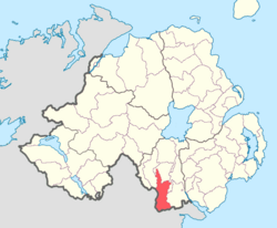
 Location of Fews Upper, County Armagh, Northern Ireland. | |
| Sovereign state | United Kingdom |
| Country | Northern Ireland |
| County | Armagh |
Fews Upper (from Irish na Feá/Feadha, meaning 'the woods')[2] is a barony in County Armagh, Northern Ireland. It lies in the south of the county bordering the Republic of Ireland with its southern and south-western borders. It is bordered by four other baronies in Northern Ireland: Armagh to the west; Fews Lower to the north and west; Orior Lower to the north-west; and Orior Upper to the east.[3] It also borders three baronies in the Republic of Ireland: Cremorne to the west; Dundalk Upper to the south; and Farney to the south-west. Fews Lower and Upper formed the barony of The Fews until it was sub-divided.
Geographical features
[edit]The Fews Mountains run through both Fews Lower and Upper, with the range's highest peak, Carrigatuke (also known as Armaghbrague Mountain), standing at 1,200 ft., located in Fews Lower.[4] The County Water and Clarbane River both flow through Fews Upper. The Ballynacarry Bridge crosses the River Fane which is on the border between County Armagh and County Monaghan.[1][5]
List of settlements
[edit]Below is a list of settlements in Fews Upper:[1]
Towns
[edit]Villages and population centres
[edit]- Ballsmill
- Cullyhanna
- Newtownhamilton
- Silverbridge
- Whitecross
List of civil parishes
[edit]Below is a list of civil parishes in Fews Upper:[6]
- Ballymyre
- Creggan
- Lisnadill (split with the barony of Armagh and Fews Lower)
- Newtownhamilton
References
[edit]- ^ a b c "Fews Upper". Placenames Database of Ireland. Department of Community, Rural and Gaeltacht Affairs. Retrieved 8 June 2011.
- ^ Placenames Database of Ireland
- Anthony David Mills (9 October 2003). A Dictionary of British Place-names. Oxford University Press. ISBN 9780191578472. Retrieved 24 July 2012.
- A Dictionary of Celtic Mythology. Oxford Reference. - ^ PRONI Baronies of Northern Ireland
- ^ "Atlas and Cyclopedia of Ireland (1900)". Library Ireland. Retrieved 8 June 2011.
- ^ "A37/N53 Cross-Border Ballynacarry Bridge - feasibility study". Border Ireland. Retrieved 8 June 2011.
- ^ "PRONI Civil Parishes of County Armagh". Archived from the original on 16 May 2008. Retrieved 28 September 2010.
- "Baronies and civil parishes of County Armagh". Archived from the original on 17 February 2010. Retrieved 6 February 2011.

